


What lures us to the Detroit River is also what makes it difficult to describe. Its depth, its changeability, its impenetrability to land creatures, all make it a suitable object of contemplation. It is a three-dimensional zen koan where you can fish. Or, as Mark Wallace, President of the Detroit Riverfront Conservancy puts it, it’s “a campfire that never goes out.” Whatever the metaphor, the river forces us to approach it obliquely, and we end up talking about things contiguous to the river itself like the riverbanks and islands that reflect or absorb it in different ways.
It’s hard to overstate the Detroit River’s importance for the city. Wallace told me that Antoine de la Mothe Cadillac stopped in Detroit because it provided the best landing for his boat, the Canadian side was too swampy. In addition, Oren Gelderloos, a professor of environmental science from the University of Michigan Dearborn, says that the bend in the river allowed defenders to see a good way upstream and downstream, leading to the establishment of Fort Wayne. The bluff at what’s now Fort Street Presbyterian Church on 3rd Street provided the French with a similar defensive position, and the city developed around it. From the long and narrow ribbon farms that allowed for river frontage to the strong presence of the underground railroad and steel mills that helped fuel the auto boom, there isn’t much Detroit history that isn’t somehow defined by the river. Today, the riverfront lies at the center of the city’s development, and how we think about the river and what we choose to do there will leave a major impression on the Detroit of the future.
Professor Gelderloos is a man who has spent a bit of time thinking about the river in all its massive dimensions. He has deduced that every year the Detroit River moves a volume of water about 67.7 times the size of Lake Erie. That’s a lot of water. He seems just as drawn to those points where land and river come together in strange harmony, in particular that repository of industry and folklore known as Zug Island
“I really enjoy seeing the operation of Zug Island,” he says, “although I don’t like the effects of it. People say you enjoy that? Well, it’s where our society comes from … we don’t have steel without it.”
For those unfamiliar, Zug Island is a man-made piece of land on the western border of the city. It’s controlled by the U.S. Steel Corporation where they produce large quantities of the metal. The island’s inaccessibility has inspired conspiracy theories about secret prisons and at least one local musical act, Zug Izland, who are affiliated with the Insane Clown Posse and refer to their fans as “Zuggalos.” Fanning the flames of this weirdness are reports that the island was the source of a strange “hum” that tormented the residents of Windsor and various downriver communities starting in 2011 and likely claimed a much larger listenership than Zug Izland themselves.
Of course, Zug Island is a perfectly logical subject to study for an environmental scientist and encapsulates the various issues at play in our river (which nearly every expert I spoke with reminded me was not really a river, but a strait or connecting channel between lakes). Zug Island depends on the river and the boats that cheaply deliver the inputs for its furnaces, including taconite, lime, and coal, and it mostly seems to co-exist with riverine biology. Although the furnaces on the island contribute to the air pollution in Del Ray and downriver that make them some of the most polluted zip codes in the state, the overall water quality in the river has been steadily improving since the 1940s, leading to the rebound of species like the Lake Sturgeon. As Gelderloos and others point out, the biggest source of river pollution aside from the upstream lakes is our own combined municipal sewer system. Zug Island is also part of an industrial landscape that is waning, freeing up space for parks, natural areas, and the kind of wetlands that have been almost entirely eliminated in the last two hundred years.
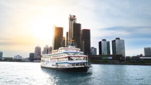
In terms of land use, The Detroit RiverFront Conservancy has led the way for the rehabilitation of the riverfront in Detroit. Following in the footsteps of other successful operations like the Central Park Conservancy, it’s a public/private partnership that involves businesses, non-profits, and city government. Since its inception, the DRFC has helped construct and maintain the Detroit River Walk that runs from the Renaissance Center to Belle Isle. The former Uniroyal site just west of Belle Isle is one significant interruption due to be added as public space soon.
The River Walk has transformed Detroit in the last few years by replacing industry and derelict properties on the river and reconnecting the city with its most significant landmark. It’s hard to quantify the success of the space, but on summer days it attracts a broad cross-section of the area’s population, including families visiting the Outdoor Adventure Center, anglers, bikers, runners, and so on. As much as the river and natural areas at Belle Isle and Milliken State Park engage people, the primary draw at Rivard, GM, and Hart plazas seems to be other people. These are the sort of public squares that provide a sense of connection to the life of the city, which are sometimes under-appreciated in discussions of parks and open space.
Wallace adds that the success of the River Walk was part of an intentional strategy that began with hundreds of public meetings before the project even started and continued with diverse programming after the space was established, much of it free. He also identifies enticing first time visitors and families as keys to bringing people down. “Your first time coming to the River Walk you probably came with a friend or you came to participate in a program, and since then, you’ve probably come by yourself,” he says.
As for families, he says this is a “natural network” that helps get the word out. He also sees it as an important factor in the civic success of the space, “sitting side by side with someone while you watch your kids play is a great way to break down some of the barriers that are really prevalent in most US communities, including Detroit.”
The impact of bringing all these people to the river could engender more than just a love for recreation. “It’s a positive feedback system. Good things produce good things,” as Gelderloos says. Martha Gruell, who works with the Wildlife Habitat Council helping businesses and other organizations improve the ecology of their properties, says, “Any way that we can get people involved in looking and thinking about nature helps us and helps them make some decisions that are going to be good for policy-making down the road.”
An important part of Gruell’s work is promoting the “softening of the shoreline”, which involves the literal removal of sea walls and other barriers to provide wetland habitat and help filter out pollutants. Of course, this also takes us back into the realm of metaphor. For years nearly all the shoreline on the Detroit side of the river has been fortified somehow, making industry possible, but cutting people off from the river and putting up a mental wall where the river is concerned.
For her part, Gruell says she feels most connected to the Detroit River when she’s on Belle Isle. “In a way, the island is sort of a piece of the river,” she says, “and has had the river flowing through it for most of its history.” She adds, “If you really think about Detroit and this part of the Great Lakes, you’re mostly in a place where you look (at the river) over the edge of a concrete wall. So having a place where the river is sort of more alive and is coming to and fro along those lagoons around Belle Isle is really nice.”
Gruell thinks that it could help restore some regional pride if people know they have a healthy river where fish are spawning and migratory birds and monarch butterflies visit the shoreline. People in neighborhoods like Del Ray may also experience the Detroit River Walk and wonder why they can’t have access to similar spaces. Everyone I spoke with for this article said that industry and nature could and indeed must co-exist on the Detroit River. However, future disagreements over land use are likely to center on development, which seems to be following the River Walk east from downtown at a rapid clip.
To its credit, the City of Detroit Planning and Development department seems to be on board with keeping a large amount of the east Riverfront as public space. This will include a beach near Milliken State Park. In all eight acres of land south of Atwater Street are slated to be added as park space. Proposed greenways on Joseph Campau and between Mt Elliot and East Grand Boulevard will feed into this area.
Still, these plans are not written and stone and the interests of economic development are likely to weigh on planners and city officials. How we negotiate creating room for riverbanks and wetlands versus providing valuable real estate for other uses will likely determine what the riverfront looks and feels like for years to come.


[…] VanDeHay, from Riverside Kayak Connection in Wyandotte, started kayaking in the Detroit River after coming here from a small […]